Trail Walking Dangolsheim - 67 Dangolsheim Dinsheim sur Bruche - Photo

67 Dangolsheim Dinsheim sur Bruche

 LUTZMarc
LUTZMarc

User

© OpenStreetMap contributors
Length
Length
22 km
Max alt
Max alt
358 m
Uphill gradient
Uphill gradient
579 m
Km-Effort
Km-Effort  
30 km
Min alt
Min alt
173 m
Downhill gradient
Downhill gradient
579 m
Boucle
Boucle
Yes
Creation date :
2018-04-17 18:54:11.232
Updated on :
2018-04-17 18:54:11.232

(0 Reviews)

Walking
Walking
5h03
Difficulty : Medium

Scan this QR Code to open this trail in the SityTrail application

FREE GPS app for hiking

Logo SityTrail SityTrail

IGN / Geographical institutes

Download SityTrail from the App Store Download SityTrail from Google Play

Logo SityTrail SityTrail Plus

The world is yours!

Download SityTrail from the App Store Download SityTrail from Google Play Download SityTrail on Huawei AppGallery

About

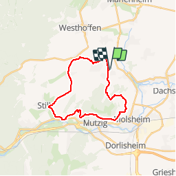
Trail Walking of 22 km to be discovered at Grand Est, Bas-Rhin, Dangolsheim. This trail is proposed by LUTZMarc.

Description

Boucle autour du fort de Mutzig.
Magnifique point de vue tout le long du parcours entre colline sèches et vignes.  A faire en hiver  au printemps ou en automne.
Évitez les fortes chaleurs d'été,  très peu de partie ombragée .
Restaurant  au km 11,2 Anatable à Dinsheim sur Bruche.
Réservation fortement conseillé.

Elevation profile

Photos

Positioning

Country:
France
Region :
Grand Est
Department/Province :
Bas-Rhin
Municipality :
Dangolsheim
Location:
Unknown
Start:(UTM)
387214 ; 5381322 (32U) N.


Close
My subscriptions