


St Aygulf

aljac
User
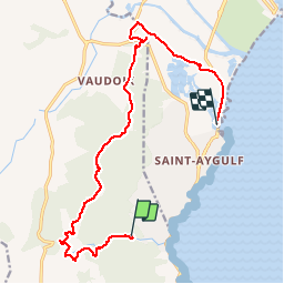

Length
15 km

Max alt
247 m

Uphill gradient
320 m
Km-Effort
19.3 km

Min alt
-1 m

Downhill gradient
336 m
Boucle
No
Creation date :
2018-04-17 19:28:22.249
Updated on :
2018-04-17 19:28:22.249
5h00
Difficulty : Unknown

FREE GPS app for hiking
 SityTrail
IGN / Geographical institutes
SityTrail Plus
The world is yours!
About
Trail Other activity of 15 km to be discovered at Provence-Alpes-Côte d'Azur, Var, Roquebrune-sur-Argens. This trail is proposed by aljac.
Positioning
Country:
France
Region :
Provence-Alpes-Côte d'Azur
Department/Province :
Var
Municipality :
Roquebrune-sur-Argens
Location:
Unknown
Start:(Dec)
Start:(UTM)
313784 ; 4804350 (32T) N.
Comments