


aubagne

micheleuvrard
User
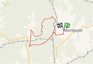

Length
8.2 km

Max alt
366 m

Uphill gradient
149 m
Km-Effort
10.1 km

Min alt
275 m

Downhill gradient
149 m
Boucle
Yes
Creation date :
2018-04-17 19:33:02.774
Updated on :
2018-04-17 19:33:02.774
2h05
Difficulty : Unknown

FREE GPS app for hiking
 SityTrail
IGN / Geographical institutes
SityTrail Plus
The world is yours!
About
Trail Walking of 8.2 km to be discovered at Auvergne-Rhône-Alpes, Drôme, Montjoyer. This trail is proposed by micheleuvrard.
Positioning
Country:
France
Region :
Auvergne-Rhône-Alpes
Department/Province :
Drôme
Municipality :
Montjoyer
Location:
Unknown
Start:(Dec)
Start:(UTM)
646876 ; 4926506 (31T) N.
Comments