


RS Oroix village

LouisROGER
User GUIDE
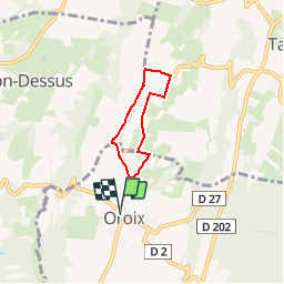

Length
4.7 km

Max alt
370 m

Uphill gradient
30 m
Km-Effort
5.1 km

Min alt
352 m

Downhill gradient
30 m
Boucle
Yes
Creation date :
2018-04-17 19:41:31.26
Updated on :
2018-04-17 19:41:31.26
1h30
Difficulty : Easy

FREE GPS app for hiking
 SityTrail
IGN / Geographical institutes
SityTrail Plus
The world is yours!
About
Trail Walking of 4.7 km to be discovered at Occitania, Hautespyrenees, Oroix. This trail is proposed by LouisROGER.
Description
Rando santé 10avril2018
Positioning
Country:
France
Region :
Occitania
Department/Province :
Hautespyrenees
Municipality :
Oroix
Location:
Unknown
Start:(Dec)
Start:(UTM)
740652 ; 4798585 (30T) N.
Comments