


egly

olivieraron
User
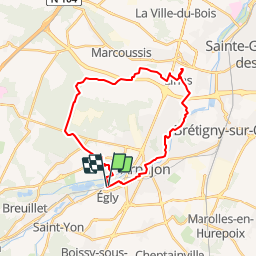

Length
25 km

Max alt
172 m

Uphill gradient
350 m
Km-Effort
30 km

Min alt
39 m

Downhill gradient
355 m
Boucle
Yes
Creation date :
2019-01-14 09:42:39.494
Updated on :
2019-01-14 09:42:39.511
8h20
Difficulty : Unknown

FREE GPS app for hiking
 SityTrail
IGN / Geographical institutes
SityTrail Plus
The world is yours!
About
Trail Other activity of 25 km to be discovered at Ile-de-France, Essonne, Égly. This trail is proposed by olivieraron.
Positioning
Country:
France
Region :
Ile-de-France
Department/Province :
Essonne
Municipality :
Égly
Location:
Unknown
Start:(Dec)
Start:(UTM)
442636 ; 5381319 (31U) N.
Comments