


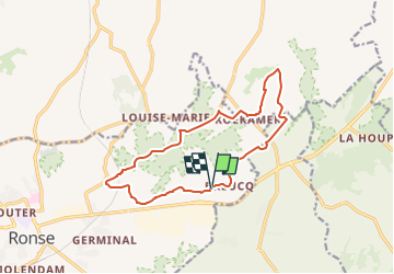
Printhut.be ruiterroute 12km

Evasaegerman
User

Length
12.3 km

Max alt
162 m

Uphill gradient
199 m
Km-Effort
15 km

Min alt
39 m

Downhill gradient
197 m
Boucle
Yes
Creation date :
2018-04-17 20:17:17.864
Updated on :
2018-04-17 20:17:17.864
3h00
Difficulty : Unknown

FREE GPS app for hiking
 SityTrail
IGN / Geographical institutes
SityTrail Plus
The world is yours!
About
Trail Other activity of 12.3 km to be discovered at Flanders, East Flanders, Ronse. This trail is proposed by Evasaegerman.
Positioning
Country:
Belgium
Region :
Flanders
Department/Province :
East Flanders
Municipality :
Ronse
Location:
Ronse
Start:(Dec)
Start:(UTM)
546467 ; 5623056 (31U) N.
Comments