


Castrum St Jean

Seylinn
User
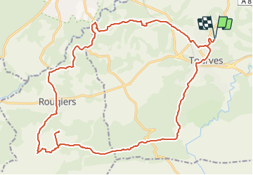

Length
27 km

Max alt
602 m

Uphill gradient
567 m
Km-Effort
35 km

Min alt
291 m

Downhill gradient
567 m
Boucle
Yes
Creation date :
2018-04-17 20:37:40.915
Updated on :
2018-04-17 20:37:40.915
4h17
Difficulty : Difficult

FREE GPS app for hiking
 SityTrail
IGN / Geographical institutes
SityTrail Plus
The world is yours!
About
Trail Equestrian of 27 km to be discovered at Provence-Alpes-Côte d'Azur, Var, Tourves. This trail is proposed by Seylinn.
Description
Dénivelé constant, terrain difficile à cheval.
Voir autre itinéraire.
Positioning
Country:
France
Region :
Provence-Alpes-Côte d'Azur
Department/Province :
Var
Municipality :
Tourves
Location:
Unknown
Start:(Dec)
Start:(UTM)
737094 ; 4811083 (31T) N.
Comments