


de pontcey a pontcey par chemilly

nicolasdresse
User
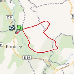

Length
6 km

Max alt
271 m

Uphill gradient
86 m
Km-Effort
7.2 km

Min alt
204 m

Downhill gradient
87 m
Boucle
Yes
Creation date :
2018-09-29 20:52:12.689
Updated on :
2018-09-29 20:52:12.7
2h02
Difficulty : Easy

FREE GPS app for hiking
 SityTrail
IGN / Geographical institutes
SityTrail Plus
The world is yours!
About
Trail Walking of 6 km to be discovered at Bourgogne-Franche-Comté, Haute-Saône, Pontcey. This trail is proposed by nicolasdresse.
Positioning
Country:
France
Region :
Bourgogne-Franche-Comté
Department/Province :
Haute-Saône
Municipality :
Pontcey
Location:
Unknown
Start:(Dec)
Start:(UTM)
277045 ; 5280009 (32T) N.
Comments