


PREPA M&R cmcas SullyLoire

MarcheEtReve
User

Length
10.5 km

Max alt
118 m

Uphill gradient
61 m
Km-Effort
11.3 km

Min alt
106 m

Downhill gradient
61 m
Boucle
No
Creation date :
2018-04-17 21:05:40.079
Updated on :
2018-04-17 21:05:40.079
10m
Difficulty : Unknown

FREE GPS app for hiking
 SityTrail
IGN / Geographical institutes
SityTrail Plus
The world is yours!
About
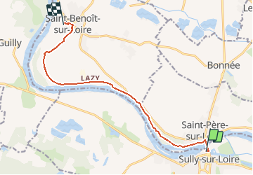
Trail Other activity of 10.5 km to be discovered at Centre-Loire Valley, Loiret, Sully-sur-Loire. This trail is proposed by MarcheEtReve.
Description
PREPA rando CMCAS 010718<br>
dép.: Sully, aire de pique-nique Chemin de la Levée,<br>
arr.: St-Benoit, parking du Calvaire.
Positioning
Country:
France
Region :
Centre-Loire Valley
Department/Province :
Loiret
Municipality :
Sully-sur-Loire
Location:
Unknown
Start:(Dec)
Start:(UTM)
452973 ; 5290702 (31T) N.
Comments