


Marolles les Buis 15.23

togolo28
User
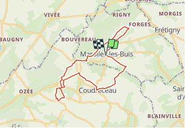

Length
15.2 km

Max alt
236 m

Uphill gradient
278 m
Km-Effort
18.9 km

Min alt
133 m

Downhill gradient
276 m
Boucle
Yes
Creation date :
2018-04-17 21:12:36.25
Updated on :
2018-06-18 15:26:09.053
4h05
Difficulty : Easy

FREE GPS app for hiking
 SityTrail
IGN / Geographical institutes
SityTrail Plus
The world is yours!
About
Trail Walking of 15.2 km to be discovered at Centre-Loire Valley, Eure-et-Loir, Marolles-les-Buis. This trail is proposed by togolo28.
Positioning
Country:
France
Region :
Centre-Loire Valley
Department/Province :
Eure-et-Loir
Municipality :
Marolles-les-Buis
Location:
Unknown
Start:(Dec)
Start:(UTM)
346491 ; 5358567 (31U) N.
Comments