Trail Walking Mimet - 
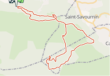
Massif de l'Etoile -Figuière - Photo
 ARPF
ARPF

User

© OpenStreetMap contributors
Length
Length
14.6 km
Max alt
Max alt
772 m
Uphill gradient
Uphill gradient
786 m
Km-Effort
Km-Effort  
25 km
Min alt
Min alt
294 m
Downhill gradient
Downhill gradient
789 m
Boucle
Boucle
Yes
Creation date :
2018-04-17 21:14:10.315
Updated on :
2018-04-17 21:14:10.315

(0 Reviews)

Walking
Walking
5h12
Difficulty : Difficult

Scan this QR Code to open this trail in the SityTrail application

FREE GPS app for hiking

Logo SityTrail SityTrail

IGN / Geographical institutes

Download SityTrail from the App Store Download SityTrail from Google Play

Logo SityTrail SityTrail Plus

The world is yours!

Download SityTrail from the App Store Download SityTrail from Google Play Download SityTrail on Huawei AppGallery

About

Trail Walking of 14.6 km to be discovered at Provence-Alpes-Côte d'Azur, Bouches-du-Rhône, Mimet. This trail is proposed by ARPF.

Description

   Pénibilité  :  P 2 .    Technicité : T 2 .     Distance   :   15 km  .                    Dénivelé cumulé positif :    850 m .    Temps de marche         :   5 h 30 .  09-03-2018 AMDifficultés particulières  :   montée pentue , et descente caillouteuse ! .

Elevation profile

Positioning

Country:
France
Region :
Provence-Alpes-Côte d'Azur
Department/Province :
Bouches-du-Rhône
Municipality :
Mimet
Location:
Unknown
Start:(UTM)
701654 ; 4809413 (31T) N.


Close
My subscriptions