


Nivelles_golf de la Tournette_Grambais

denissculier
User
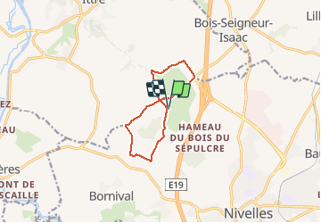

Length
8.3 km

Max alt
153 m

Uphill gradient
110 m
Km-Effort
9.8 km

Min alt
97 m

Downhill gradient
112 m
Boucle
Yes
Creation date :
2018-04-17 21:40:48.996
Updated on :
2020-12-25 11:55:08.356
2h03
Difficulty : Medium

FREE GPS app for hiking
 SityTrail
IGN / Geographical institutes
SityTrail Plus
The world is yours!
About
Trail Nordic walking of 8.3 km to be discovered at Wallonia, Walloon Brabant, Nivelles. This trail is proposed by denissculier.
Positioning
Country:
Belgium
Region :
Wallonia
Department/Province :
Walloon Brabant
Municipality :
Nivelles
Location:
Nivelles
Start:(Dec)
Start:(UTM)
591450 ; 5608718 (31U) N.
Comments