


Le clapas roquelaure

limo12
User
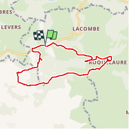

Length
8.2 km

Max alt
811 m

Uphill gradient
308 m
Km-Effort
12.3 km

Min alt
537 m

Downhill gradient
310 m
Boucle
Yes
Creation date :
2018-04-17 21:43:12.606
Updated on :
2018-04-17 21:43:12.606
2h32
Difficulty : Easy

FREE GPS app for hiking
 SityTrail
IGN / Geographical institutes
SityTrail Plus
The world is yours!
About
Trail Walking of 8.2 km to be discovered at Occitania, Aveyron, Lassouts. This trail is proposed by limo12.
Positioning
Country:
France
Region :
Occitania
Department/Province :
Aveyron
Municipality :
Lassouts
Location:
Unknown
Start:(Dec)
Start:(UTM)
484175 ; 4927009 (31T) N.
Comments