


LES NEYROLLES

Filkine
User

Length
6.8 km

Max alt
700 m

Uphill gradient
181 m
Km-Effort
9.2 km

Min alt
527 m

Downhill gradient
182 m
Boucle
Yes
Creation date :
2018-04-17 21:46:58.255
Updated on :
2018-04-17 21:46:58.255
1h42
Difficulty : Easy

FREE GPS app for hiking
 SityTrail
IGN / Geographical institutes
SityTrail Plus
The world is yours!
About
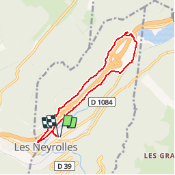
Trail Walking of 6.8 km to be discovered at Auvergne-Rhône-Alpes, Ain, Les Neyrolles. This trail is proposed by Filkine.
Description
Départ du parking de l'ancien Intermarché-les Glacières de Sylans et retour aux Neyrolles
Positioning
Country:
France
Region :
Auvergne-Rhône-Alpes
Department/Province :
Ain
Municipality :
Les Neyrolles
Location:
Unknown
Start:(Dec)
Start:(UTM)
703386 ; 5113212 (31T) N.
Comments