


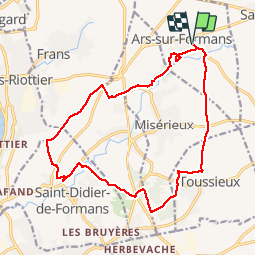
Ars-Sur-Formans (17,4 km - D. 205 m)

Thomasdanielle
User

Length
17.5 km

Max alt
266 m

Uphill gradient
215 m
Km-Effort
20 km

Min alt
195 m

Downhill gradient
214 m
Boucle
Yes
Creation date :
2018-04-17 22:15:38.236
Updated on :
2018-04-17 22:15:38.236
4h23
Difficulty : Very easy

FREE GPS app for hiking
 SityTrail
IGN / Geographical institutes
SityTrail Plus
The world is yours!
About
Trail Walking of 17.5 km to be discovered at Auvergne-Rhône-Alpes, Ain, Ars-sur-Formans. This trail is proposed by Thomasdanielle.
Description
D/A parking centre village
17,4 km - D. 205 m
Positioning
Country:
France
Region :
Auvergne-Rhône-Alpes
Department/Province :
Ain
Municipality :
Ars-sur-Formans
Location:
Unknown
Start:(Dec)
Start:(UTM)
641020 ; 5094937 (31T) N.
Comments