


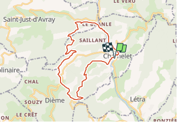
Chamelet (16 km - D. 659 m)

Thomasdanielle
User

Length
16 km

Max alt
726 m

Uphill gradient
627 m
Km-Effort
24 km

Min alt
304 m

Downhill gradient
627 m
Boucle
Yes
Creation date :
2018-04-17 22:26:18.731
Updated on :
2018-04-17 22:26:18.731
5h08
Difficulty : Medium

FREE GPS app for hiking
 SityTrail
IGN / Geographical institutes
SityTrail Plus
The world is yours!
About
Trail Walking of 16 km to be discovered at Auvergne-Rhône-Alpes, Rhône, Chamelet. This trail is proposed by Thomasdanielle.
Description
D/A/ parking du pressoir
16 km-D. 659 m
Positioning
Country:
France
Region :
Auvergne-Rhône-Alpes
Department/Province :
Rhône
Municipality :
Chamelet
Location:
Unknown
Start:(Dec)
Start:(UTM)
616817 ; 5093152 (31T) N.
Comments