


RCY Base Seine-Ecole

gdruet
User
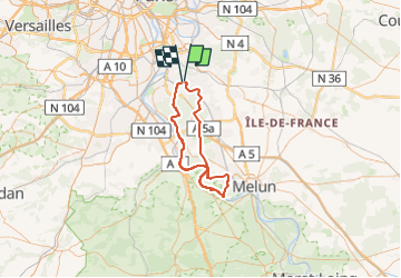

Length
66 km

Max alt
99 m

Uphill gradient
585 m
Km-Effort
74 km

Min alt
32 m

Downhill gradient
581 m
Boucle
No
Creation date :
2018-04-17 23:07:49.812
Updated on :
2025-03-31 16:34:46.9
1h48
Difficulty : Unknown

FREE GPS app for hiking
 SityTrail
IGN / Geographical institutes
SityTrail Plus
The world is yours!
About
Trail Cycle of 66 km to be discovered at Ile-de-France, Essonne, Yerres. This trail is proposed by gdruet.
Positioning
Country:
France
Region :
Ile-de-France
Department/Province :
Essonne
Municipality :
Yerres
Location:
Unknown
Start:(Dec)
Start:(UTM)
462351 ; 5395707 (31U) N.
Comments