


chemins tremplins à l'envers

mapomme
User
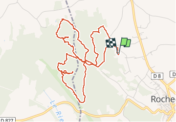

Length
7 km

Max alt
192 m

Uphill gradient
155 m
Km-Effort
9.1 km

Min alt
117 m

Downhill gradient
155 m
Boucle
Yes
Creation date :
2018-04-17 23:22:55.501
Updated on :
2018-04-17 23:22:55.501
2h08
Difficulty : Medium

FREE GPS app for hiking
 SityTrail
IGN / Geographical institutes
SityTrail Plus
The world is yours!
About
Trail Mountain bike of 7 km to be discovered at Auvergne-Rhône-Alpes, Drôme, Rochegude. This trail is proposed by mapomme.
Description
Attention: découverte de chemins qu'il faut prendre à l'envers ! Ne pas suivre tel quel !!!!
Positioning
Country:
France
Region :
Auvergne-Rhône-Alpes
Department/Province :
Drôme
Municipality :
Rochegude
Location:
Unknown
Start:(Dec)
Start:(UTM)
645324 ; 4901760 (31T) N.
Comments