


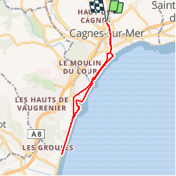
Cagnes - Antibes

papajp
User

Length
13 km

Max alt
28 m

Uphill gradient
102 m
Km-Effort
14.3 km

Min alt
0 m

Downhill gradient
100 m
Boucle
Yes
Creation date :
2019-02-16 19:06:19.916
Updated on :
2019-02-16 19:06:19.951
2h28
Difficulty : Unknown

FREE GPS app for hiking
 SityTrail
IGN / Geographical institutes
SityTrail Plus
The world is yours!
About
Trail Walking of 13 km to be discovered at Provence-Alpes-Côte d'Azur, Maritime Alps, Cagnes-sur-Mer. This trail is proposed by papajp.
Photos

Positioning
Country:
France
Region :
Provence-Alpes-Côte d'Azur
Department/Province :
Maritime Alps
Municipality :
Cagnes-sur-Mer
Location:
Unknown
Start:(Dec)
Start:(UTM)
350955 ; 4836330 (32T) N.
Comments