


roche guyon

olivieraron
User
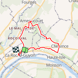

Length
13 km

Max alt
149 m

Uphill gradient
337 m
Km-Effort
17.5 km

Min alt
16 m

Downhill gradient
335 m
Boucle
Yes
Creation date :
2019-01-14 09:42:37.965
Updated on :
2019-01-14 09:42:38.015
3h00
Difficulty : Unknown

FREE GPS app for hiking
 SityTrail
IGN / Geographical institutes
SityTrail Plus
The world is yours!
About
Trail Other activity of 13 km to be discovered at Ile-de-France, Val-d'Oise, La Roche-Guyon. This trail is proposed by olivieraron.
Positioning
Country:
France
Region :
Ile-de-France
Department/Province :
Val-d'Oise
Municipality :
La Roche-Guyon
Location:
Unknown
Start:(Dec)
Start:(UTM)
400070 ; 5437247 (31U) N.
Comments