


L'Hermitière 16.67

togolo28
User
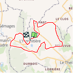

Length
16.6 km

Max alt
206 m

Uphill gradient
347 m
Km-Effort
21 km

Min alt
119 m

Downhill gradient
345 m
Boucle
Yes
Creation date :
2018-04-17 23:45:21.522
Updated on :
2018-06-25 12:30:46.892
4h35
Difficulty : Medium

FREE GPS app for hiking
 SityTrail
IGN / Geographical institutes
SityTrail Plus
The world is yours!
About
Trail Walking of 16.6 km to be discovered at Normandy, Orne, Val-au-Perche. This trail is proposed by togolo28.
Positioning
Country:
France
Region :
Normandy
Department/Province :
Orne
Municipality :
Val-au-Perche
Location:
Unknown
Start:(Dec)
Start:(UTM)
325258 ; 5350274 (31U) N.
Comments