


Arles-StGilles

gk@icedd.be
User
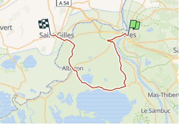

Length
45 km

Max alt
22 m

Uphill gradient
167 m
Km-Effort
47 km

Min alt
-2 m

Downhill gradient
169 m
Boucle
No
Creation date :
2018-04-17 23:50:41.553
Updated on :
2018-04-17 23:50:41.553
2h47
Difficulty : Easy

FREE GPS app for hiking
 SityTrail
IGN / Geographical institutes
SityTrail Plus
The world is yours!
About
Trail Cycle of 45 km to be discovered at Provence-Alpes-Côte d'Azur, Bouches-du-Rhône, Arles. This trail is proposed by gk@icedd.be.
Positioning
Country:
France
Region :
Provence-Alpes-Côte d'Azur
Department/Province :
Bouches-du-Rhône
Municipality :
Arles
Location:
Unknown
Start:(Dec)
Start:(UTM)
631373 ; 4837070 (31T) N.
Comments