Trail Walking Orée-d'Anjou - LPR La Varenne 110418 - Photo
© OpenStreetMap contributors
Length
Length
14.7 km
Max alt
Max alt
80 m
Uphill gradient
Uphill gradient
195 m
Km-Effort
Km-Effort  
17.3 km
Min alt
Min alt
4 m
Downhill gradient
Downhill gradient
196 m
Boucle
Boucle
Yes
Creation date :
2018-04-18 00:14:07.274
Updated on :
2018-04-18 00:14:07.274

(0 Reviews)

Walking
Walking
3h19
Difficulty : Medium

Scan this QR Code to open this trail in the SityTrail application

FREE GPS app for hiking

Logo SityTrail SityTrail

IGN / Geographical institutes

Download SityTrail from the App Store Download SityTrail from Google Play

Logo SityTrail SityTrail World

The world is yours!

Download SityTrail from the App Store Download SityTrail from Google Play Download SityTrail on Huawei AppGallery

About

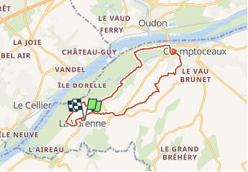
Trail Walking of 14.7 km to be discovered at Pays de la Loire, Maine-et-Loire, Orée-d'Anjou. This trail is proposed by boboss4x4.

Description

La Varenne

Elevation profile

Positioning

Country:
France
Region :
Pays de la Loire
Department/Province :
Maine-et-Loire
Municipality :
Orée-d'Anjou
Location:
Unknown
Start:(UTM)
626944 ; 5241349 (30T) N.

Trails nearby

Trail On foot Divatte-sur-Loire - La Haute Chapelle - Photo
On foot
PRO

On foot

Easy
Divatte-sur-Loire, Pays de la Loire, Loire-Atlantique, France
10.5 km | 12.4 km-effort
2h 48min
No
Trail On foot Divatte-sur-Loire - La Haute Chapelle (variante) - Photo
On foot
PRO

On foot

Easy
Divatte-sur-Loire, Pays de la Loire, Loire-Atlantique, France
9.3 km | 10.7 km-effort
2h 26min
No
Trail Walking Divatte-sur-Loire - La Chapelle-Basse-Mer - nord-ouest - Photo
Walking
TEFFRA

Walking

Easy
(1)
Divatte-sur-Loire, Pays de la Loire, Loire-Atlantique, France
9.1 km | 9.6 km-effort
2h 8min
Yes
Trail On foot Oudon - PR la vallée du Havre - Photo
On foot
PRO

On foot

Easy
Oudon, Pays de la Loire, Loire-Atlantique, France
6 km | 6.9 km-effort
1h 33min
Yes
Trail Walking Orée-d'Anjou - Le prieuré Champtoceaux  - Photo
Walking
Poulpy77

Walking

Medium
Orée-d'Anjou, Pays de la Loire, Maine-et-Loire, France
6.3 km | 7.9 km-effort
2h 45min
Yes
Trail Walking Orée-d'Anjou - Parcours médiéval  - Champtoceaux - Photo
Walking
tracegps

Walking

Easy
Orée-d'Anjou, Pays de la Loire, Maine-et-Loire, France
3.3 km | 4.6 km-effort
1h 0min
Yes
Trail Walking Oudon - Les bords de Loire entre Oudon et Ancenis - Photo
Walking
tracegps

Walking

Medium
Oudon, Pays de la Loire, Loire-Atlantique, France
22 km | 24 km-effort
5h 0min
Yes
Trail Walking Le Cellier - Le Cellier 2011-05-22 - Photo
Walking
phila128

Walking

Easy
(2)
Le Cellier, Pays de la Loire, Loire-Atlantique, France
16.4 km | 19.9 km-effort
Unknown
Yes
Trail Walking Le Cellier - Cellier Coulées Clermont - Photo
Walking
TonioNantes

Walking

Medium
Le Cellier, Pays de la Loire, Loire-Atlantique, France
8.4 km | 10.5 km-effort
2h 25min
Yes


Close
My subscriptions