Trail Mountain bike Saint-Jean-de-Laur - Le causse au-dessus de Cajarc  - Photo

Le causse au-dessus de Cajarc

 lolote46
lolote46

User

© OpenStreetMap contributors
Length
Length
40 km
Max alt
Max alt
398 m
Uphill gradient
Uphill gradient
810 m
Km-Effort
Km-Effort  
51 km
Min alt
Min alt
148 m
Downhill gradient
Downhill gradient
811 m
Boucle
Boucle
Yes
Creation date :
2018-04-18 00:23:59.251
Updated on :
2018-04-18 00:23:59.251

(0 Reviews)

Mountain bike
Mountain bike
--
Difficulty : Medium

Scan this QR Code to open this trail in the SityTrail application

FREE GPS app for hiking

Logo SityTrail SityTrail

IGN / Geographical institutes

Download SityTrail from the App Store Download SityTrail from Google Play

Logo SityTrail SityTrail World

The world is yours!

Download SityTrail from the App Store Download SityTrail from Google Play Download SityTrail on Huawei AppGallery

About

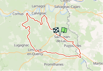
Trail Mountain bike of 40 km to be discovered at Occitania, Lot, Saint-Jean-de-Laur. This trail is proposed by lolote46.

Description

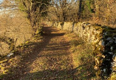
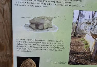
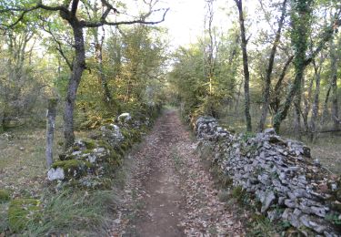
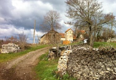
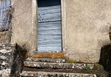
Un départ sur le causse, à Saint-Jean-de-Laur, au sud de Cajarc, permet de profiter sans difficulté en début de parcours des chemins bordés de murettes du plateau. Malgré une allure rapide, de nombreuses cazelles et dolmens vous rappellent la richesse et la beauté de cet endroit. Appréciez au détour toutes les maisons en pierre sèche, tout en restant vigilant aux cailloux parfois glissants de ces chemins praticables en toute saison...Un passage par Limogne engage enfin sur des sentiers monotraces, puis un passage sur des crêtes vous permet d’apprécier la diversité du paysage… jusqu’à une première descente rapide vers le Lot... pour repartir de plus belle du pied des fortifications du château de Cenevières, à l’assaut des falaises … Le portage, il est là, la longueur du pourcentage élevé vient user la résistance de tous les vaillants vététistes … Mais la récompense est bien au rendez-vous, en crête, vue imprenable sur les méandres du Lot …Une autre descente vous permettra d’apprécier le single bordé de végétation couverte de mousse qui vous fera progressivement remonter vers Saint-Jean-de-Laur.

Elevation profile

Positioning

Country:
France
Region :
Occitania
Department/Province :
Lot
Municipality :
Saint-Jean-de-Laur
Location:
Unknown
Start:(UTM)
406870 ; 4919550 (31T) N.

Trails nearby

Trail Walking Limogne-en-Quercy - Limogne Malecargue variante  - Photo
Walking
GUIDE
antignacs

Walking

Very easy
(1)
Limogne-en-Quercy, Occitania, Lot, France
9.7 km | 11.8 km-effort
2h 14min
Yes
Trail Walking Saint-Jean-de-Laur - Saint Jacques Étape 15 - Photo
Walking
Jean-MarieFaux

Walking

Very easy
(1)
Saint-Jean-de-Laur, Occitania, Lot, France
26 km | 31 km-effort
7h 8min
No
Trail Mountain bike Limogne-en-Quercy - circuit des Dolmens - Photo
Mountain bike
Forsans

Mountain bike

Easy
Limogne-en-Quercy, Occitania, Lot, France
8.3 km | 10.4 km-effort
58min
Yes
Trail Walking Calvignac - calvignac cenevieres - Photo
Walking
yves12

Walking

Medium
Calvignac, Occitania, Lot, France
19.4 km | 28 km-effort
5h 29min
Yes
Trail Walking Limogne-en-Quercy - Mon Compostelle septième étape - Photo
Walking
Ardeiserois

Walking

Difficult
Limogne-en-Quercy, Occitania, Lot, France
49 km | 61 km-effort
10h 30min
No
Trail Walking Limogne-en-Quercy - Lac Aurié et dolmen - Photo
Walking
clotioneb

Walking

Very easy
Limogne-en-Quercy, Occitania, Lot, France
5.5 km | 6.9 km-effort
1h 14min
Yes
Trail Walking Limogne-en-Quercy - Fontaine de Malecargue - Photo
Walking
clotioneb

Walking

Very easy
Limogne-en-Quercy, Occitania, Lot, France
4.5 km | 5.5 km-effort
53min
Yes
Trail Walking Limogne-en-Quercy - circuit des cabanes Limogne - Photo
Walking
hartmannpat

Walking

Easy
Limogne-en-Quercy, Occitania, Lot, France
3.4 km | 3.9 km-effort
1h 30min
Yes
Trail Walking Saint-Jean-de-Laur - Limogne au nord-est  - Photo
Walking
GUIDE
antignacs

Walking

Easy
Saint-Jean-de-Laur, Occitania, Lot, France
15.6 km | 19.2 km-effort
3h 37min
Yes


Close
My subscriptions