


autour de st julien se raz 30km

gaille38
User
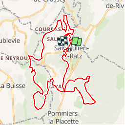

Length
27 km

Max alt
890 m

Uphill gradient
935 m
Km-Effort
39 km

Min alt
558 m

Downhill gradient
935 m
Boucle
Yes
Creation date :
2018-04-18 00:26:46.329
Updated on :
2018-04-18 00:26:46.329
2h30
Difficulty : Medium

FREE GPS app for hiking
 SityTrail
IGN / Geographical institutes
SityTrail Plus
The world is yours!
About
Trail Mountain bike of 27 km to be discovered at Auvergne-Rhône-Alpes, Isère, La Sure en Chartreuse. This trail is proposed by gaille38.
Positioning
Country:
France
Region :
Auvergne-Rhône-Alpes
Department/Province :
Isère
Municipality :
La Sure en Chartreuse
Location:
Unknown
Start:(Dec)
Start:(UTM)
708510 ; 5025243 (31T) N.
Comments