


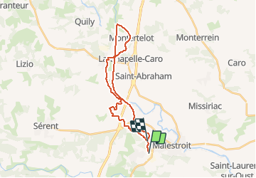
Montertelot Malestroit

chasle
User

Length
25 km

Max alt
76 m

Uphill gradient
241 m
Km-Effort
28 km

Min alt
16 m

Downhill gradient
257 m
Boucle
No
Creation date :
2018-04-18 00:28:52.541
Updated on :
2018-04-18 00:28:52.541
6h06
Difficulty : Easy

FREE GPS app for hiking
 SityTrail
IGN / Geographical institutes
SityTrail Plus
The world is yours!
About
Trail Walking of 25 km to be discovered at Brittany, Morbihan, Saint-Marcel. This trail is proposed by chasle.
Positioning
Country:
France
Region :
Brittany
Department/Province :
Morbihan
Municipality :
Saint-Marcel
Location:
Unknown
Start:(Dec)
Start:(UTM)
544520 ; 5294774 (30T) N.
Comments