


Malestroit Pleucadeuc

chasle
User
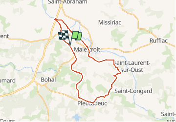

Length
28 km

Max alt
109 m

Uphill gradient
366 m
Km-Effort
33 km

Min alt
10 m

Downhill gradient
366 m
Boucle
Yes
Creation date :
2018-04-18 00:28:53.858
Updated on :
2018-04-18 00:28:53.858
7h08
Difficulty : Easy

FREE GPS app for hiking
 SityTrail
IGN / Geographical institutes
SityTrail Plus
The world is yours!
About
Trail Walking of 28 km to be discovered at Brittany, Morbihan, Saint-Marcel. This trail is proposed by chasle.
Positioning
Country:
France
Region :
Brittany
Department/Province :
Morbihan
Municipality :
Saint-Marcel
Location:
Unknown
Start:(Dec)
Start:(UTM)
544405 ; 5295612 (30T) N.
Comments