


2011-11-13 09h00m11

ludo39
User
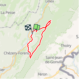

Length
23 km

Max alt
1707 m

Uphill gradient
1289 m
Km-Effort
40 km

Min alt
737 m

Downhill gradient
1305 m
Boucle
Yes
Creation date :
2014-12-10 00:00:00.0
Updated on :
2014-12-10 00:00:00.0
8h04
Difficulty : Medium

FREE GPS app for hiking
 SityTrail
IGN / Geographical institutes
SityTrail Plus
The world is yours!
About
Trail Walking of 23 km to be discovered at Auvergne-Rhône-Alpes, Ain, Chézery-Forens. This trail is proposed by ludo39.
Positioning
Country:
France
Region :
Auvergne-Rhône-Alpes
Department/Province :
Ain
Municipality :
Chézery-Forens
Location:
Unknown
Start:(Dec)
Start:(UTM)
723719 ; 5126091 (31T) N.
Comments