


ranrupt15

oscar1
User
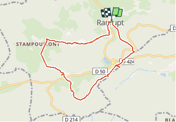

Length
8 km

Max alt
670 m

Uphill gradient
318 m
Km-Effort
12.2 km

Min alt
510 m

Downhill gradient
314 m
Boucle
Yes
Creation date :
2018-04-18 00:38:08.378
Updated on :
2019-02-06 20:59:32.801
--
Difficulty : Very easy

FREE GPS app for hiking
 SityTrail
IGN / Geographical institutes
SityTrail Plus
The world is yours!
About
Trail On foot of 8 km to be discovered at Grand Est, Bas-Rhin, Ranrupt. This trail is proposed by oscar1.
Positioning
Country:
France
Region :
Grand Est
Department/Province :
Bas-Rhin
Municipality :
Ranrupt
Location:
Unknown
Start:(Dec)
Start:(UTM)
366613 ; 5359422 (32U) N.
Comments