


Chipilly CAF

reneperrin
User

Length
21 km

Max alt
96 m

Uphill gradient
199 m
Km-Effort
23 km

Min alt
30 m

Downhill gradient
205 m
Boucle
Yes
Creation date :
2018-04-18 00:40:02.279
Updated on :
2018-04-18 00:40:02.279
5h04
Difficulty : Easy

FREE GPS app for hiking
 SityTrail
IGN / Geographical institutes
SityTrail Plus
The world is yours!
About
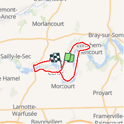
Trail Walking of 21 km to be discovered at Hauts-de-France, Somme, Chipilly. This trail is proposed by reneperrin.
Description
2 boucles de randonnée autour de Chipilly vallée de la Somme.
Positioning
Country:
France
Region :
Hauts-de-France
Department/Province :
Somme
Municipality :
Chipilly
Location:
Unknown
Start:(Dec)
Start:(UTM)
474840 ; 5528591 (31U) N.
Comments