


Châteaulin - Le long du canal

cron
User
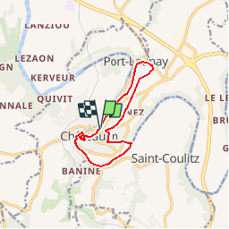

Length
10.2 km

Max alt
86 m

Uphill gradient
146 m
Km-Effort
12.2 km

Min alt
3 m

Downhill gradient
145 m
Boucle
Yes
Creation date :
2018-04-18 00:40:07.919
Updated on :
2018-04-18 00:40:07.919
2h45
Difficulty : Easy

FREE GPS app for hiking
 SityTrail
IGN / Geographical institutes
SityTrail Plus
The world is yours!
About
Trail Walking of 10.2 km to be discovered at Brittany, Finistère, Châteaulin. This trail is proposed by cron.
Positioning
Country:
France
Region :
Brittany
Department/Province :
Finistère
Municipality :
Châteaulin
Location:
Unknown
Start:(Dec)
Start:(UTM)
419243 ; 5338843 (30U) N.
Comments