


Juillé (17,6 km - D. 687 m)

Thomasdanielle
User
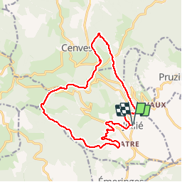

Length
17.6 km

Max alt
738 m

Uphill gradient
639 m
Km-Effort
26 km

Min alt
346 m

Downhill gradient
638 m
Boucle
Yes
Creation date :
2018-06-26 10:30:43.078
Updated on :
2018-06-26 10:30:43.078
5h33
Difficulty : Medium

FREE GPS app for hiking
 SityTrail
IGN / Geographical institutes
SityTrail Plus
The world is yours!
About
Trail Walking of 17.6 km to be discovered at Auvergne-Rhône-Alpes, Rhône, Jullié. This trail is proposed by Thomasdanielle.
Description
D/A centre du village parking monument aux mort
16/04/2018
Positioning
Country:
France
Region :
Auvergne-Rhône-Alpes
Department/Province :
Rhône
Municipality :
Jullié
Location:
Unknown
Start:(Dec)
Start:(UTM)
629371 ; 5122321 (31T) N.
Comments