


SAINT-LYPHARD_01_KERHINET_L'EGUIGNAC_20180422

patrickdanilo
User
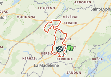

Length
12 km

Max alt
20 m

Uphill gradient
82 m
Km-Effort
13.1 km

Min alt
2 m

Downhill gradient
85 m
Boucle
Yes
Creation date :
2019-02-15 16:26:06.551
Updated on :
2022-11-24 09:06:56.608
2h53
Difficulty : Very easy

FREE GPS app for hiking
 SityTrail
IGN / Geographical institutes
SityTrail Plus
The world is yours!
About
Trail Walking of 12 km to be discovered at Pays de la Loire, Loire-Atlantique, Saint-Lyphard. This trail is proposed by patrickdanilo.
Description
Type: Circuit-44-Loire-Atlantique
Départ de Kerhinet
Photos

Positioning
Country:
France
Region :
Pays de la Loire
Department/Province :
Loire-Atlantique
Municipality :
Saint-Lyphard
Location:
Unknown
Start:(Dec)
Start:(UTM)
549150 ; 5245855 (30T) N.
Comments