


massifs des écrins miroir de fetouls

lefrancm
User
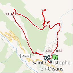

Length
7 km

Max alt
2041 m

Uphill gradient
569 m
Km-Effort
14.6 km

Min alt
1466 m

Downhill gradient
570 m
Boucle
Yes
Creation date :
2014-12-10 00:00:00.0
Updated on :
2014-12-10 00:00:00.0
3h18
Difficulty : Easy

FREE GPS app for hiking
 SityTrail
IGN / Geographical institutes
SityTrail Plus
The world is yours!
About
Trail Walking of 7 km to be discovered at Auvergne-Rhône-Alpes, Isère, Saint-Christophe-en-Oisans. This trail is proposed by lefrancm.
Positioning
Country:
France
Region :
Auvergne-Rhône-Alpes
Department/Province :
Isère
Municipality :
Saint-Christophe-en-Oisans
Location:
Unknown
Start:(Dec)
Start:(UTM)
277269 ; 4982177 (32T) N.
Comments
