


ATH

Titounet
User
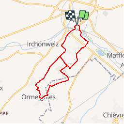

Length
12.4 km

Max alt
70 m

Uphill gradient
108 m
Km-Effort
13.9 km

Min alt
30 m

Downhill gradient
109 m
Boucle
Yes
Creation date :
2018-06-26 10:59:56.684
Updated on :
2018-06-26 10:59:56.684
--
Difficulty : Easy

FREE GPS app for hiking
 SityTrail
IGN / Geographical institutes
SityTrail Plus
The world is yours!
About
Trail Walking of 12.4 km to be discovered at Wallonia, Hainaut, Ath. This trail is proposed by Titounet.
Description
Départ: gare de Ath
Positioning
Country:
Belgium
Region :
Wallonia
Department/Province :
Hainaut
Municipality :
Ath
Location:
Ath (section)
Start:(Dec)
Start:(UTM)
555044 ; 5608782 (31U) N.
Comments