


circuit des moines

fitz2014
User
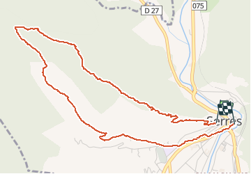

Length
6 km

Max alt
1044 m

Uphill gradient
340 m
Km-Effort
10.7 km

Min alt
659 m

Downhill gradient
383 m
Boucle
Yes
Creation date :
2018-06-26 12:31:07.521
Updated on :
2020-08-02 12:14:43.929
2h25
Difficulty : Easy

FREE GPS app for hiking
 SityTrail
IGN / Geographical institutes
SityTrail Plus
The world is yours!
About
Trail Walking of 6 km to be discovered at Provence-Alpes-Côte d'Azur, Hautes-Alpes, Serres. This trail is proposed by fitz2014.
Positioning
Country:
France
Region :
Provence-Alpes-Côte d'Azur
Department/Province :
Hautes-Alpes
Municipality :
Serres
Location:
Unknown
Start:(Dec)
Start:(UTM)
716164 ; 4923170 (31T) N.
Comments