


D/Gorges de Franchard-Gorges du Houx

katiab
User
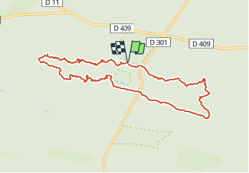

Length
10 km

Max alt
142 m

Uphill gradient
130 m
Km-Effort
11.8 km

Min alt
94 m

Downhill gradient
130 m
Boucle
Yes
Creation date :
2018-06-26 12:31:15.907
Updated on :
2021-05-11 15:56:39.171
4h00
Difficulty : Medium

FREE GPS app for hiking
 SityTrail
IGN / Geographical institutes
SityTrail Plus
The world is yours!
About
Trail Walking of 10 km to be discovered at Ile-de-France, Seine-et-Marne, Fontainebleau. This trail is proposed by katiab.
Photos


Positioning
Country:
France
Region :
Ile-de-France
Department/Province :
Seine-et-Marne
Municipality :
Fontainebleau
Location:
Unknown
Start:(Dec)
Start:(UTM)
473008 ; 5361812 (31U) N.
Comments