


120219 - Anet

domelisa78
User
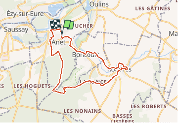

Length
15.4 km

Max alt
141 m

Uphill gradient
212 m
Km-Effort
18.3 km

Min alt
65 m

Downhill gradient
214 m
Boucle
Yes
Creation date :
2018-06-26 12:42:29.168
Updated on :
2018-06-26 12:42:29.168
3h57
Difficulty : Easy

FREE GPS app for hiking
 SityTrail
IGN / Geographical institutes
SityTrail Plus
The world is yours!
About
Trail Walking of 15.4 km to be discovered at Centre-Loire Valley, Eure-et-Loir, Anet. This trail is proposed by domelisa78.
Positioning
Country:
France
Region :
Centre-Loire Valley
Department/Province :
Eure-et-Loir
Municipality :
Anet
Location:
Unknown
Start:(Dec)
Start:(UTM)
385997 ; 5412551 (31U) N.
Comments