


2018-05-25 Rando CVA Champerboux vers La Fage Reel

holtzv
User GUIDE
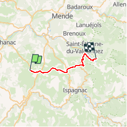

Length
22 km

Max alt
1213 m

Uphill gradient
643 m
Km-Effort
30 km

Min alt
934 m

Downhill gradient
381 m
Boucle
No
Creation date :
2018-06-26 12:47:22.632
Updated on :
2018-06-26 12:47:22.632
3h47
Difficulty : Unknown

FREE GPS app for hiking
 SityTrail
IGN / Geographical institutes
SityTrail Plus
The world is yours!
About
Trail Equestrian of 22 km to be discovered at Occitania, Lozère, Gorges du Tarn Causses. This trail is proposed by holtzv.

Positioning
Country:
France
Region :
Occitania
Department/Province :
Lozère
Municipality :
Gorges du Tarn Causses
Location:
Unknown
Start:(Dec)
Start:(UTM)
532679 ; 4917485 (31T) N.
Comments