


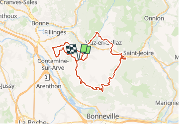
VTT(74)-Autour de Peillonnex

HG74250
User

Length
33 km

Max alt
974 m

Uphill gradient
970 m
Km-Effort
46 km

Min alt
536 m

Downhill gradient
971 m
Boucle
Yes
Creation date :
2018-06-26 12:51:55.13
Updated on :
2020-01-04 17:48:42.494
2h58
Difficulty : Medium

FREE GPS app for hiking
 SityTrail
IGN / Geographical institutes
SityTrail Plus
The world is yours!
About
Trail Mountain bike of 33 km to be discovered at Auvergne-Rhône-Alpes, Upper Savoy, Peillonnex. This trail is proposed by HG74250.
Positioning
Country:
France
Region :
Auvergne-Rhône-Alpes
Department/Province :
Upper Savoy
Municipality :
Peillonnex
Location:
Unknown
Start:(Dec)
Start:(UTM)
297265 ; 5112026 (32T) N.
Comments