


Cezas

ARVIEU
User
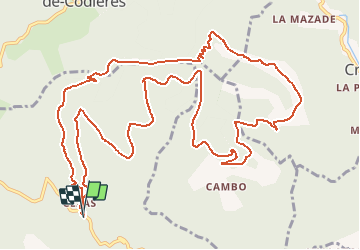

Length
16.4 km

Max alt
912 m

Uphill gradient
651 m
Km-Effort
25 km

Min alt
530 m

Downhill gradient
649 m
Boucle
Yes
Creation date :
2018-06-26 12:53:21.443
Updated on :
2018-06-26 12:53:21.443
6h00
Difficulty : Medium

FREE GPS app for hiking
 SityTrail
IGN / Geographical institutes
SityTrail Plus
The world is yours!
About
Trail Other activity of 16.4 km to be discovered at Occitania, Gard, Sumène. This trail is proposed by ARVIEU.
Positioning
Country:
France
Region :
Occitania
Department/Province :
Gard
Municipality :
Sumène
Location:
Unknown
Start:(Dec)
Start:(UTM)
562450 ; 4869442 (31T) N.
Comments