


Caroux

ARVIEU
User
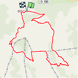

Length
13.9 km

Max alt
1090 m

Uphill gradient
719 m
Km-Effort
24 km

Min alt
685 m

Downhill gradient
716 m
Boucle
Yes
Creation date :
2018-06-26 12:53:36.111
Updated on :
2018-06-26 12:53:36.111
5h00
Difficulty : Difficult

FREE GPS app for hiking
 SityTrail
IGN / Geographical institutes
SityTrail Plus
The world is yours!
About
Trail Walking of 13.9 km to be discovered at Occitania, Hérault, Rosis. This trail is proposed by ARVIEU.
Positioning
Country:
France
Region :
Occitania
Department/Province :
Hérault
Municipality :
Rosis
Location:
Unknown
Start:(Dec)
Start:(UTM)
498038 ; 4828641 (31T) N.
Comments