


20.04.2018 - Gouessant, Jospinet, Dahouët

babeth35
User
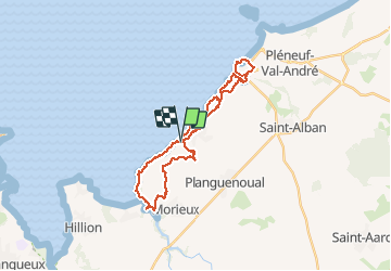

Length
28 km

Max alt
97 m

Uphill gradient
483 m
Km-Effort
34 km

Min alt
0 m

Downhill gradient
482 m
Boucle
Yes
Creation date :
2018-06-26 13:16:27.001
Updated on :
2020-07-20 15:06:34.299
7h08
Difficulty : Difficult

FREE GPS app for hiking
 SityTrail
IGN / Geographical institutes
SityTrail Plus
The world is yours!
About
Trail Walking of 28 km to be discovered at Brittany, Côtes-d'Armor, Lamballe-Armor. This trail is proposed by babeth35.
Photos


Positioning
Country:
France
Region :
Brittany
Department/Province :
Côtes-d'Armor
Municipality :
Lamballe-Armor
Location:
Planguenoual
Start:(Dec)
Start:(UTM)
529137 ; 5377564 (30U) N.
Comments