


lac Wildenstein

Derrendinger
User
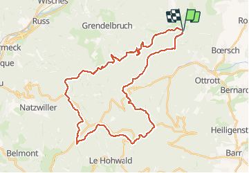

Length
42 km

Max alt
1045 m

Uphill gradient
1146 m
Km-Effort
57 km

Min alt
320 m

Downhill gradient
1141 m
Boucle
Yes
Creation date :
2018-06-26 13:18:44.444
Updated on :
2020-07-29 15:24:12.912
3h40
Difficulty : Very difficult

FREE GPS app for hiking
 SityTrail
IGN / Geographical institutes
SityTrail Plus
The world is yours!
About
Trail Mountain bike of 42 km to be discovered at Grand Est, Bas-Rhin, Rosheim. This trail is proposed by Derrendinger.
Description
Avec Cathy
Positioning
Country:
France
Region :
Grand Est
Department/Province :
Bas-Rhin
Municipality :
Rosheim
Location:
Unknown
Start:(Dec)
Start:(UTM)
381734 ; 5371942 (32U) N.
Comments