


lavigny (chapelle)

nicolas.gx
User
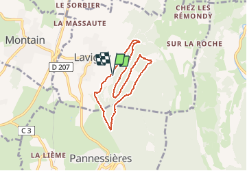

Length
6.6 km

Max alt
518 m

Uphill gradient
216 m
Km-Effort
9.5 km

Min alt
338 m

Downhill gradient
211 m
Boucle
Yes
Creation date :
2018-06-26 13:18:48.721
Updated on :
2018-06-26 13:18:48.721
1h36
Difficulty : Medium

FREE GPS app for hiking
 SityTrail
IGN / Geographical institutes
SityTrail Plus
The world is yours!
About
Trail Walking of 6.6 km to be discovered at Bourgogne-Franche-Comté, Jura, Lavigny. This trail is proposed by nicolas.gx.
Positioning
Country:
France
Region :
Bourgogne-Franche-Comté
Department/Province :
Jura
Municipality :
Lavigny
Location:
Unknown
Start:(Dec)
Start:(UTM)
698792 ; 5176616 (31T) N.
Comments