


Farguet

jlrayon
User
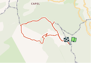

Length
9.7 km

Max alt
1128 m

Uphill gradient
233 m
Km-Effort
12.8 km

Min alt
943 m

Downhill gradient
234 m
Boucle
Yes
Creation date :
2018-06-26 13:30:50.282
Updated on :
2020-05-16 16:50:33.138
3h46
Difficulty : Unknown

FREE GPS app for hiking
 SityTrail
IGN / Geographical institutes
SityTrail Plus
The world is yours!
About
Trail Walking of 9.7 km to be discovered at Provence-Alpes-Côte d'Azur, Maritime Alps, Peille. This trail is proposed by jlrayon.

Positioning
Country:
France
Region :
Provence-Alpes-Côte d'Azur
Department/Province :
Maritime Alps
Municipality :
Peille
Location:
Unknown
Start:(Dec)
Start:(UTM)
374965 ; 4854754 (32T) N.
Comments