


j3 haut allier montbonnet 30k

ophness
User
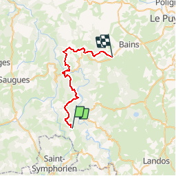

Length
30 km

Max alt
1213 m

Uphill gradient
1153 m
Km-Effort
45 km

Min alt
592 m

Downhill gradient
1077 m
Boucle
No
Creation date :
2018-06-26 13:32:56.73
Updated on :
2018-06-26 13:32:56.73
4h16
Difficulty : Unknown

FREE GPS app for hiking
 SityTrail
IGN / Geographical institutes
SityTrail Plus
The world is yours!
About
Trail Equestrian of 30 km to be discovered at Auvergne-Rhône-Alpes, Haute-Loire, Alleyras. This trail is proposed by ophness.
Positioning
Country:
France
Region :
Auvergne-Rhône-Alpes
Department/Province :
Haute-Loire
Municipality :
Alleyras
Location:
Unknown
Start:(Dec)
Start:(UTM)
552316 ; 4971014 (31T) N.
Comments