


caramy 2018

ARPF
User
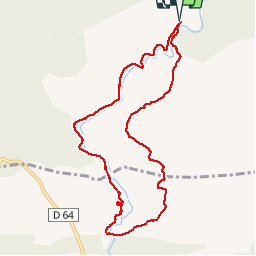

Length
10 km

Max alt
428 m

Uphill gradient
235 m
Km-Effort
13.2 km

Min alt
278 m

Downhill gradient
239 m
Boucle
Yes
Creation date :
2018-06-26 13:37:23.343
Updated on :
2018-06-26 13:37:23.343
5h23
Difficulty : Medium

FREE GPS app for hiking
 SityTrail
IGN / Geographical institutes
SityTrail Plus
The world is yours!
About
Trail Walking of 10 km to be discovered at Provence-Alpes-Côte d'Azur, Var, Tourves. This trail is proposed by ARPF.
Positioning
Country:
France
Region :
Provence-Alpes-Côte d'Azur
Department/Province :
Var
Municipality :
Tourves
Location:
Unknown
Start:(Dec)
Start:(UTM)
737442 ; 4808367 (31T) N.
Comments