


Barthelasse 05_2018

kephas
User
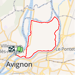

Length
15.5 km

Max alt
35 m

Uphill gradient
124 m
Km-Effort
17.2 km

Min alt
14 m

Downhill gradient
124 m
Boucle
Yes
Creation date :
2018-06-26 13:42:29.084
Updated on :
2018-06-26 13:42:29.084
3h47
Difficulty : Easy

FREE GPS app for hiking
 SityTrail
IGN / Geographical institutes
SityTrail Plus
The world is yours!
About
Trail Walking of 15.5 km to be discovered at Provence-Alpes-Côte d'Azur, Vaucluse, Avignon. This trail is proposed by kephas.


Positioning
Country:
France
Region :
Provence-Alpes-Côte d'Azur
Department/Province :
Vaucluse
Municipality :
Avignon
Location:
Unknown
Start:(Dec)
Start:(UTM)
644611 ; 4868634 (31T) N.
Comments