


St Joseph des bancs

collot
User
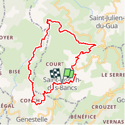

Length
18.5 km

Max alt
1125 m

Uphill gradient
752 m
Km-Effort
29 km

Min alt
595 m

Downhill gradient
758 m
Boucle
Yes
Creation date :
2018-06-26 13:44:19.891
Updated on :
2018-06-26 13:44:19.891
7h44
Difficulty : Difficult

FREE GPS app for hiking
 SityTrail
IGN / Geographical institutes
SityTrail Plus
The world is yours!
About
Trail Walking of 18.5 km to be discovered at Auvergne-Rhône-Alpes, Ardèche, Saint-Joseph-des-Bancs. This trail is proposed by collot.
Positioning
Country:
France
Region :
Auvergne-Rhône-Alpes
Department/Province :
Ardèche
Municipality :
Saint-Joseph-des-Bancs
Location:
Unknown
Start:(Dec)
Start:(UTM)
611774 ; 4954652 (31T) N.
Comments